No featured offers available
We feature offers with an Add to Cart button when an offer meets our high standards for:
- Quality Price,
- Reliable delivery option, and
- Seller who offers good customer service
Garmin eTrex 30x, Handheld GPS Navigator with 3-axis Compass, Enhanced Memory and Resolution, 2.2-inch Color Display, Water Resistant
Brand | Garmin |
Vehicle Service Type | Car |
Screen Size | 2.2 Inches |
Special Feature | Waterproof |
Connectivity Technology | ANT+ |
Map Type | City Tour |
Sport | Camping & Hiking |
Included Components | GPS Navigator |
Audio Output Mode | Stereo |
Battery Life | 25 Hours |
About this item
- UPGRADED DISPLAY Features a 2.2” 65K color sunglight readable display offering increased resolution (240 x 320 pixels). Physical dimensions: 2.1" x 4.0" x 1.3" (5.4 x 10.3 x 3.3 cm)
- LOAD MORE MAPS Large 3.7 GB of internal memory and microSD card slot lets you load a variety of maps, including TOPO 24K, HuntView, BlueChart g2, City Navigator NT and BirdsEye Satellite Imagery (subscription required)
- PRELOADED BASEMAP Includes a worldwide basemap with shaded relief
- BUILT IN SENSORS eTrex 30x adds a built in 3 axis tilt compensated electronic compass and a barometric altimeter which tracks changes in pressure to pinpoint your precise altitude, and you even can use it to plot barometric pressure over time
- WIRELESS Wirelessly share your waypoints, tracks, routes and geocaches with other compatible devices simply press “send” to transfer your information also wirelessly connects to compatible Garmin devices, including VIRB and accessory sensors
Similar items that may ship from close to you
- Garmin eTrex 32x, Rugged Handheld GPS NavigatorFREE Shipping by AmazonGet it as soon as Wednesday, Mar 20
- Garmin 010-02256-00 eTrex 22x, Rugged Handheld GPS Navigator, Black/NavyAmazon's Choicein Handheld GPS UnitsFREE Shipping by AmazonGet it as soon as Wednesday, Mar 20
- Garmin eTrex® SE GPS Handheld Navigator, Extra Battery Life, Wireless Connectivity, Multi-GNSS Support, Sunlight Readable ScreenFREE Shipping by AmazonGet it as soon as Wednesday, Mar 20
- Garmin GPSMAP 67i Rugged GPS Handheld with inReach® Satellite Technology, Two-Way Messaging, Interactive SOS, MappingFREE Shipping by AmazonGet it as soon as Wednesday, Mar 20
- Garmin GPSMAP 66i, GPS Handheld and Satellite Communicator, Featuring TopoActive mapping and inReach Technology, MultiFREE Shipping by AmazonGet it as soon as Wednesday, Mar 20
- Adventure Medical Kits Trauma Pak First Aid Kit with QuikClot SpongeFREE Shipping on orders over $35 shipped by AmazonGet it as soon as Wednesday, Mar 20
Important information
To report an issue with this product or seller, click here.
Top Brand: Garmin
Product Description
The new eTrex 30x is our upgraded version of the popular eTrex 30, with enhanced screen resolution and expandedinternal memory so you can download a greater variety of maps than ever. This rugged, dependable GPS retains the easeof-use and affordability that eTrex is legendary for, with an array of compatible mounts for use on ATVs, bicycles, boatsand cars. The new eTrex 30x also has the ability to track both GPS and GLONASS satellites simultaneously. Add to that a3-axis tilt-compensated electronic compass and barometric altimeter, and you’re ready to confidently go anywhere.
Compare with similar items
This Item Garmin eTrex 30x, Handheld GPS Navigator with 3-axis Compass, Enhanced Memory and Resolution, 2.2-inch Color Display, Water Resistant | Recommendations | dummy | dummy | dummy | |
Try again! Added to Cart Add to Cart | Try again! Added to Cart Add to Cart | Try again! Added to Cart Add to Cart | Try again! Added to Cart Add to Cart | ||
Price | — | $149.99$149.99 | $599.99$599.99 | -40% $119.99$119.99 New Price: $200.45 | -18% $139.95$139.95 New Price: $169.99 |
Delivery | — | Get it as soon as Wednesday, Mar 20 | Get it as soon as Wednesday, Mar 20 | Get it as soon as Wednesday, Mar 20 | Get it as soon as Wednesday, Mar 20 |
Customer Ratings | |||||
Accuracy | 4.2 | — | 4.6 | 4.2 | 4.0 |
User interface | 3.8 | 3.5 | 3.5 | — | 4.4 |
Touch Screen | 3.4 | 3.5 | 3.3 | 4.3 | — |
Battery life | 4.5 | 4.6 | 4.6 | — | — |
Easy to use | 3.8 | — | — | 4.2 | 4.0 |
Sold By | — | Amazon.com | Amazon.com | Beach Camera Same Day Shipping | iSave Renewed |
control method | touch | — | — | voice | voice |
resolution | 240 x 320 | 480 x 272 | — | 480 x 272 | 480 x 272 |
mounting type | found in image, Dashboard Mount | Wrist Mount | Wrist Mount | found in image, Dashboard Mount | found in image, Dashboard Mount |
batteries included | ✗ | ✗ | ✓ | ✓ | ✓ |
battery average life | 25 hours | 168 hours | 165 hours | 1 hours | 1 hours |
What's in the box
Looking for specific info?
From the manufacturer
eTrex 30x is our upgraded version of the popular eTrex 30, with enhanced screen resolution for a more readable display and internal memory expanded to hold more maps. It retains the ease-of-use, durability and affordability that eTrex is legendary for and can also be used on ATVs, bicycles, boats, cars or hot air balloons.
eTrex 30x
Handheld GPS, 3-axis Compass: Better Resolution and Memory.
- Greater resolution with 240 x 320 display pixels for improved readability
- Internal memory expanded to hold more maps
- Worldwide basemap with shaded relief
- 2.2-inch, 65K color, sunlight-readable display
- 3-axis compass and barometric altimeter
eTrex
Find Fun
eTrex supports geocaching GPX files for downloading geocaches and details straight to your unit. eTrex stores and displays key information, including location, terrain, difficulty, hints and descriptions, which means no more manually entering coordinates and paper printouts.
Keep Your Fix
With its high-sensitivity, WAAS-enabled GPS receiver and HotFix satellite prediction, eTrex locates your position quickly and precisely and maintains its GPS location even in heavy cover and deep canyons.
Go Global
The eTrex series is the first-ever consumer-grade receivers that can track both GPS and GLONASS satellites simultaneously. When using GLONASS satellites, a system developed by the Russian Federation, the time it takes for the receiver to 'lock on' to a position is (on average) approximately 20 percent faster than using GPS.
Plan Your Next Trip
- Take charge of your next adventure with BaseCamp, software that lets you view and organize maps, waypoints, routes, and tracks
- This free trip-planning software even allows you to create Garmin Adventures that you can share with friends, family or fellow explorers.
- BaseCamp displays topographic map data in 2-D or 3-D on your computer screen, including contour lines and elevation profiles. It also can transfer an unlimited amount of satellite images to your device when paired with a BirdsEye Satellite Imagery subscription.
eTrex 30x | eTrex 20x | eTrex 10 | |
---|---|---|---|
Customer Reviews |
— |
— |
— |
Display size, WxH | 1.4" x 1.7" (3.5 x 4.4 cm); 2.2" diag (5.6 cm) | 1.4" x 1.7" (3.5 x 4.4 cm); 2.2" diag (5.6 cm) | 1.4" x 1.7" (3.6 x 4.3 cm); 2.2" diag (5.6 cm) |
Display resolution, WxH | 240 x 320 pixels | 240 x 320 pixels | 128 x 160 pixels |
Display type | 2.2" transflective, 65K color TFT | 2.2" transflective, 65K color TFT | transflective, monochrome |
Barometric altimeter | ✓ | ||
Electronic compass | ✓ | ||
Ability to add maps | ✓ | ✓ | |
Routes | 200 | 200 | 50 |
Track log | 10,000 points, 200 saved tracks | 10,000 points, 200 saved tracks | 10,000 points, 200 saved tracks |
Automatic routing (turn by turn routing on roads) | Yes (with optional mapping for detailed roads) | Yes (with optional mapping for detailed roads) | |
Custom maps compatible | ✓ | ✓ |
Product information
Product Dimensions | 2.1 x 4 x 1.3 inches |
---|---|
Item Weight | 5 ounces |
ASIN | B00XQE6Z92 |
Item model number | 010-01508-10 |
Batteries | 2 AA batteries required. |
Customer Reviews |
4.3 out of 5 stars |
Best Sellers Rank | #187,955 in Electronics (See Top 100 in Electronics) #409 in Handheld GPS Units |
Is Discontinued By Manufacturer | No |
Connectivity technologies | ANT+ |
Special features | Waterproof |
Other display features | Wireless |
Human Interface Input | Buttons |
Scanner Resolution | 240 x 320 |
Whats in the box | GPS Navigator |
Department | Handheld GPS Units |
Manufacturer | Garmin |
Date First Available | May 13, 2015 |
Warranty & Support
Feedback
Customer reviews
Customer Reviews, including Product Star Ratings help customers to learn more about the product and decide whether it is the right product for them.
To calculate the overall star rating and percentage breakdown by star, we don’t use a simple average. Instead, our system considers things like how recent a review is and if the reviewer bought the item on Amazon. It also analyzed reviews to verify trustworthiness.
Learn more how customers reviews work on AmazonCustomers say
Customers like the quality, tracking and battery life of the GPS. They mention that it's built well, accurate and good for trips. They also like the performance and battery. However, some complain about the maps. Opinions are mixed on value, ease of use, and size.
AI-generated from the text of customer reviews
Customers like the performance of the eTrex 30x GPS receiver. They say it works well, has a ton of great features, and is great for hiking and most outdoor sports. Customers also appreciate the alarm clock and the many features, such as the compass, altitude meter, and easy programming.
"...Everything worked well. (I think Basecamp is OK, but not as good as the older Garmin MapSource v6—discontinued.)...." Read more
"...We do a lot of back country hiking and this works great, park your car at the trail head, turn it on and press create waypoint, and take off, it..." Read more
"...Once I was able to start creating custom maps, this has worked like a charm. Internal memory is decent. I have yet to fill it up...." Read more
"...The manual is pretty basic. It has some omissions of features and doesn't have much in the way of pictures...." Read more
Customers are satisfied with the quality of the gps or navigation system. They mention that it's built well, has pretty good UI and controls, and is tough. Some say that the hardware is excellent, but the software is horrible. Overall, most are impressed with the 30x size and reliability.
"...It's very compact, it feels extremely solid and the screen is quite nice...." Read more
"Have been very impressed with the 30x size and reliability...." Read more
"Would not buy again. The hardware is excellent but the software is horrible; the online manual is even worse...." Read more
"...2. Small and light3. Robust and although I'm sure it's not waterproof to the point where you can submerge it, I use it in rain all the..." Read more
Customers like the tracking of the GPS. They mention that it's small, works great, and seems to track location accurately. Some customers also really enjoyed the tracking. The GPS is durable and good for tracking trips, mileage, and other activities. It has a great compass and altimeter, and performs exactly as advertised. It locates your position on the receiver map, and it has GLONASS and WAAS on it. It's a solid GPS for treks and has many other functions.
"...With GLONASS and WAAS on it very quickly finds my position...." Read more
"...satellite association alongside US satellites, seem to place locations more accurately and more quickly than previous systems..." Read more
"There's a lot to like about the Garmin eTrex 30x. It locks onto satellites quickly, it stays locked pretty well, it's easy to work with a single..." Read more
"...The device basically tracks all the time, which is a blessing (I've never lost a track, even when learning) and a curse..." Read more
Customers like the battery life of the gps or navigation system. They say it has a high battery life, the adjustable settings allow for efficient energy consumption, and the 2 AA battery power is fantastic.
"...I prefer the longer battery life, the 30x is supposed to get around 25 hours, it's counterpart the etrex 35 only gets 16 on a pair of AA's...." Read more
"...It features power management to maximize battery life and it has features that let you optimize it for hiking, nautical, or road use..." Read more
"...The small size is really great, and 2 AA battery power is fantastic...." Read more
"...Battery life is not the advertised 16 hours, even with the screen brightness turned down and only using it to record my tracks...." Read more
Customers are mixed about the ease of use of the gps or navigation system. Some mention that the interface is incredibly simple, and the learning curve is easy if you've already used a recent-year Garmin unit. However, others say that it is not intuitive, the instructions from Garmin are poor, and it is difficult to use the BaseCamp software. The Waypoint Manager is a little cumbersome, and there are scant and unclear user manuals.
"...Setting a course or waypoints is somewhat difficult, navigating with the joystick nub on a map is slightly awkward...." Read more
"...The screen is clear and very usable when zooming down to 800-foot scale or higher...." Read more
"...The learning curve is steep because of the poor documentation and hardware orientation...." Read more
"...Small, light weight, and easy to read...." Read more
Customers are mixed about the size of the GPS. Some mention that it's very compact, light weight, and solid, while others say that the screen is small and difficult to see.
"...It's very compact, it feels extremely solid and the screen is quite nice...." Read more
"...At any rate, this is a terrific value. Light weight, relatively low cost for a color LCD, great compatibility with 3rd party maps, and good..." Read more
"...The screen is smaller than many other more expensive units, but very usable. Great handheld Product!- - -...." Read more
"...The small size is really great, and 2 AA battery power is fantastic...." Read more
Customers have mixed opinions about the value of the product. Some say it is a good value for the cost, while others say that it is not a great deal and the birdseye subscription is totally worth it. The product is light weight and compact, but some customers find the maps to be a bit pricy.
"...At any rate, this is a terrific value. Light weight, relatively low cost for a color LCD, great compatibility with 3rd party maps, and good..." Read more
"...Small, light weight, and easy to read. Maps are expensive so do yourself a favor and get the FREE Garmin compatible maps from Gmaptool..." Read more
"This was a great GPS for the price I paid. You can pay a ton of money for a GPS, but this one has every feature that you could want and then some...." Read more
"...I would keep it if it was at least $100, but it's really expensive unit..." Read more
Customers are disappointed with the maps provided with the GPS. They say that the maps are not detailed enough, they are expensive, and the maps lack information. They also complain that the map is not up to date.
"...-Easy to upload and use geocachesCons:-The base map is pretty worthless, so you'll need to invest in good maps..." Read more
"...disappointed - accuracy was no better than phone and those built-in maps are TERRIBLE... so the plan was to return the unit...." Read more
"...map that comes preloaded is all but useless due to its extreme lack of detail and information...." Read more
"...The map it has is completely useless and unreadable...." Read more
Reviews with images
-
Top reviews
Top reviews from the United States
There was a problem filtering reviews right now. Please try again later.
It's very compact, it feels extremely solid and the screen is quite nice. The reception and accuracy are significantly better than the Garmin GPSMap 60Csx with Sirfstar III. This unit likes to be held with the screen up and not vertically, however it is less sensitive to orientation then the 60Csx, which liked to be held vertically with the antenna pointed toward the sky. With GLONASS and WAAS on it very quickly finds my position. I assume these features consume more battery life, and they do make the unit refresh at a slightly slower rate. Make sure you turn WAAS and GLONASS on if you want the fastest and most accurate position information, neither feature is on by default. I think that is a mistake on Garmins part, people pick the unit up and don't realize how accurate it can be.
I personally didn't find the unit very cumbersome to navigate through. I love that they kept the customizable data points on most of the screens. Setting a course or waypoints is somewhat difficult, navigating with the joystick nub on a map is slightly awkward. I don't usually make many changes to my route away from the computer however, just minor ones. If you do find yourself often making new routes in the field then this is a unit you should stay away from if they are going to be anything more than four or five waypoints.
The manual is pretty basic. It has some omissions of features and doesn't have much in the way of pictures. The basic menu and feature set is very similar to the 60Csx and I had figured it out pretty quickly without the manual in about two hours of casual fiddling.
The touch screen etrex units where announced right after I bought this unit, and they look pretty tempting. I however am going to stick with this unit. I have three reasons for doing that: I don't feel that I need a touch screen to do what I need to do, like I said however if you are doing a lot of route planning on the unit you may like that better. I prefer the longer battery life, the 30x is supposed to get around 25 hours, it's counterpart the etrex 35 only gets 16 on a pair of AA's. The price of the touch screen versions are slightly higher.
.
With Garmin Basecamp (the free SW program to manage maps, waypoints, etc., I had little trouble transferring my maps, waypoints (dozens), and routes (11 of them). Everything worked well. (I think Basecamp is OK, but not as good as the older Garmin MapSource v6—discontinued.)
.
This GPS loads quickly (considering my map sizes) and locks on satellites in a reasonable amount of time. The menus are customizable (click through selected pages) which allows you to set up the GPS to quickly flip through the pages you usually use (this is common to Garmin GPSs, I think). Pages have easy to update settings for selecting fields, changing maps, and contextual options. You can also change the datum sets and the coordinate systems to your liking (to match the map-set features of your mapping software or Google's mapping system for example. You can easily edit/move/change waypoints/routes and names, and change symbols, DIRECTLY on the unit's actual database using Basecamp--a great plus for units without a touch-screen. (note: Basecamp also allows backup of the unit's data to your computer hard disk.)
.
These newer units using GLONASS satellite association alongside US satellites, seem to place locations more accurately and more quickly than previous systems (you have to manually turn on the GLONASS setting from the menu).
.
The 4 GB of internal memory was enough to load my Eastern TOPO 2008 (4 States) + my Free Virginia TOPO map set without using a microSD card. The screen is clear and very usable when zooming down to 800-foot scale or higher. Once you allow Basecamp to compile and build Map image files, you can just copy them via USB connection to your hard-drive; and then, copy them to another unit (use extreme care if you do not understand what map image files are, or which directory to place them in on the Garmin unit. My second unit fired up, the first time, correctly loading my 2 map image files—without a hitch—just after I simply copied the 2 Map Image files from my HDD to the unit. (note: the unit apparently uses a slow USB 2.0 connection, so it took about 20 minutes to copy these 2 image files--about 2GBs total. Fortunately, you rarely have to copy maps/map image files)
.
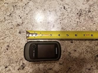
I was planning on replacing my old Garmin GPSMAP 60CSx with another similar GPS, but after using this unit, I bought a second one a couple of weeks later.) The screen is smaller than many other more expensive units, but very usable. Great handheld Product!
- - -.
Note: I would rate GPS unit use, GPS SW, Unit Setup, hiking uses, map-building, waypoint/route building and use, and Datum/Coordinate changes among the most difficult-to-understand software technologies for the typical consumer. I have seen many reviews and negative comments that reflect a misunderstanding about the capabilities of a handheld GPS, or realistic expectations about GPS systems/GPS software / or ridiculous commentary (bought a non-touch screen unit and complaining about lack of a touch screen). All of my Garmin units are accurate within 30 feet or less (according to the satellite fix on the screen) and have always placed me within 30 Yards of a marked waypoint months or years later (<90 feet max--which is close enough to see your stand or car). If you are new to using GPSs, or struggling to get it to work well, there are numerous websites offering information on general GPS setup and technology, and very specific information on building your own map sets, Datum/Coordinate selection, accuracy expectations, over-zooming issues, etc. and explanations about bearing/heading – placement accuracy/waypoint averaging – compass calibration – magnetic N compass alignment – vector turns, etc. I hope this helps some of you planning to tackle hand-held GPSs. . .
Top reviews from other countries
This was my first gps ever, and I learned to use it easily. I got some topo maps to download different areas I frequent (hiking and hunting) and the accuracy is very good. Over 5 km, I was within 3 meters on the gps location flag. Being in color was an added bonus, letting me know water from land.
Before use you must activate thr BirdsEye Satilite imagery map ( you buy it 30 $for one year subscription in the Garmin wesite) in yours device.Because it will come only blank global map without detail area. Another important tips is the the satilite imagery comes with three types of quality. Normal, high & higher. The high is run the device average speed and higher is occupied more memory and very detailed imagery but the device work very slowly. Rechargeable batteries are the best choice for this device.
Edge800は、しばしば暴走し、リセットスイッチがないので大変不便でしたが、Etrexはほとんど暴走しない。
動作が単純で、電源が入っている間ログを取り続けるので、スタートボタンの押し忘れでログが取れなかったなどの失敗がない。
電源が単三電池なのも、長時間のブルベ大会などでは大変重宝する。
電子コンパスが内蔵されているので、交差点で止まっている時も、地図の方向が大体合っているのも便利(Etrex 20との比較)。
温度計が内蔵されていないのが残念ですが、自分には余り大きな問題ではない。
純正の自転車アダプターから外す時苦労する、という意見があったが、おしりを少し持ち上げて、おしりを頭側へ、げんこつで軽くたたいてやると簡単に外れます。